
Report of CA-WN Public Meeting 20 November

November's guest speaker was Adrian Jarvis, Chair of Leicestershire CPRE (Council for the Protection of Rural England)1. Prior to semi-retirement, Adrian had a long career in the energy industry and his talk to us on energy and land use encompassed both his enjoyment of the countryside and his experience in the energy sector. The meeting was recorded and is available to watch on YouTube2, and the slides will soon be available to download3.
Present: Alison Barlow, Andrew Stevens, David Garlick, Geoff Carverhill, Harry Mellor, Helen Dyson, Hilary Hunt, James Hadfield, Jane Wood, Jean Troy, Maria Lee, Martin Coombs, Mike Longman, Rupert Frost, Rupert Knowles, Stewart Manley, Teresa Cox
Apologies: Eluned Lewis-Nicholl, Jonathan Harris, Leonie Beale
Introduction
Adrian is here in his role as Chair of Leicestershire CPRE, which he has been doing for just over a year, but his background is in the energy sector where he had a 40 year career. He left National Grid in 2018 and now just does some part-time consulting.
Adrian’s career included wholesale electricity trading and building critical national infrastructure – so he’s an ex-developer but really cares about the countryside too. He has done business development work connecting the UK to other countries, and internal programmes to make the energy industry more effective and efficient.
Context - NESO (National Energy System Operator)
Adrian ran a project to change how electricity is traded in England & Wales and then in Scotland. This system what has now morphed into NESO. It’s recently been nationalised and is now a company with the sole shareholder being the government, so it has a social obligation as well as its existing responsibility to balance supply and demand.
NESO’s Chief Operating Officer is Kayte O’Neill – a recent quote from her:
A once in a generation transformation for energy…The chance to do things differently, together.
One of NESO’s programmes is Strategic Energy Planning, focused on national and regional energy planning. Adrian is making proposals to NESO which are at the local end of the energy spectrum.
Conversations about energy can get emotive very quickly, Adrian is keen to focus on the more objective side of our energy future – no-one objects to cleaner air delivered by decarbonisation but opinions on how and when to get there differ.
Context - CPRE
CPRE has recently published a paper, Greening the Grid4, advocating principles which are very reasonable from an industry perspective and consistent with what NESO is trying to do. There is an opportunity to find better ways of working.
As CPRE Chair, Adrian talks to a lot of people with opinions about energy infrastructure e.g. where solar farms and cables should go.
For the purposes of this talk he is attempting to summarise what it seems everyone wants:
- Communities want to collaborate and be part of the conversation, rather than be dismissed
- Policy makers are concerned about lack of joined-up policy at national, regional and local levels and the difficulty of getting policy to work in the real world
- Industry tends to talk about either prosperity or being responsible stewards of the environment as if these are two different things but they’re not, lots of companies create jobs and prosperity in a responsible way.
‘Clean energy and protect the environment’
Land can be classified in line with the matrix below:
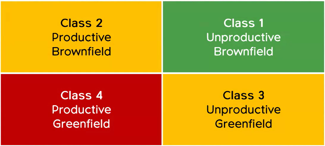
More solar on rooftops and on unproductive land is preferred by most people to using productive land, but under the current planning system the latter is cheaper. We should certainly not be putting prime agricultural land permanently out of production to produce clean energy; preference would be to build on unproductive brownfield land first and productive greenfield land last.
Transitioning to electric heating and EVs is going to generate a significant increase in demand for power, and this will require more power stations.
What could local involvement in SSEP (Strategic Spatial Energy Plan) look like?
Three steps Adrian is advocating:
- Classify local land
- Prioritise land use
- Incentivise delivery
Using a 1 sq. km case study in Leicestershire and focusing on solar power to keep it simple, there is a live pilot for this approach currently being worked on by Adrian and others.
Trying to classify and prioritise all the land in the country is a big task. NESO needs to have sufficient detail to balance supply and demand and to signal to the market where power generation is needed, but it doesn’t have resources to get into detailed land planning which could be done at a local level.
The pilot area has been chosen because it contains a wide variety of land use types, including agriculture, a railway station, roads, and a recycling plant.
The SSEP methodology issued by NESO says: “The SSEP will be developed in a way that seeks to protect and enhance the environment.”
This very much coincides with the aims of CPRE too.
The future for 70m people?
NESO is working on:
- Strategic Spatial Energy Plan – how much energy the country is going to need in future, how many heat pumps and EVS etc therefore how many power stations will be needed
- Centralised Strategic Network Plan (CSNP) – how all the power stations will be connected together
- Regional Energy Strategic Plan (RESP) – taking planning down to a lower level e.g. Northamptonshire will be in the Central England zone
NESO is not doing anything at a more detailed local level, and to cover this Adrian is advocating:
- Local Area Energy Plan (LAEP) – analysis of land looking at where power stations would ideally be sited
- Local Nature Recovery Strategy (LNRS) – not to do with energy, looks at different land types, uses and biodiversity
- Consent Planning for Regional Energy (CPRE) – how can local people have a say in where power generation will be built.
Leicestershire has recently completed a LAEP5 and LNRS6 [West Northamptonshire’s LNRS7 is due out for consultation in February 2026; as far as CA-WN is aware, there is no work going on to produce a WN LAEP].
The LAEP contains very rich data about the area - it is a business and policy focused document designed for use by community energy companies and local government. Not easy for a member of the public to use, but there is an opportunity to use it as part of local energy planning.
The view in the slide below shows the pilot square in Leicestershire, overlaid with data from the LAEP, which has been filtered to show where solar PV could be located (dark blue). This is rooftop solar on an industrial estate.
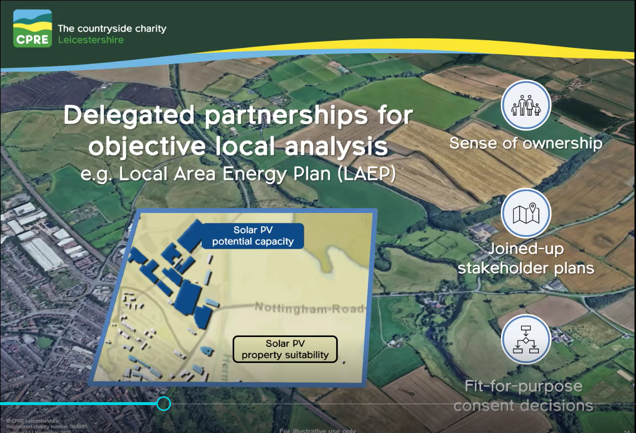
The same area has been mapped for the LNRS showing for example, SSSIs, areas of ancient woodland, and arable land, with the purpose of protecting and enhancing the natural environment.
Adrian is talking to the managers of the LAEP and LNRS projects in Leicestershire about how this data can be used to identify where we would want power stations to be built or not built.
E.g. Loughborough Station is within the square - it is brownfield productive land (Class 2 on the matrix). Putting solar canopies over the railway station car park would be very positive as it could generate power for the station itself and nearby residents. There would be restrictions to avoid impacting the current uses of the land.
Using the objective data from the LAEP and LNRS enables land in the square to be classified by priority use, for example solar on the brownfield productive industrial estate, and biodiversity, ecology and arable in the greenfield productive areas.
Some square km areas will be much simpler than this one as they might contain only one type of priority land use.
Incentivising energy generation
The energy industry works on incentives. Parts are competitive e.g. power generating companies compete in a wholesale market. The network companies are regional monopolies which are regulated by Ofgem, with schemes in place to incentivise them to do what society wants and disincentivise what society doesn’t want. Different regulatory models for different sectors – all quite complicated!
Adrian is suggesting incentives in the generation sector (i.e. power stations), so that there would be commercial incentives to do what society wants. For example permanently changing the use of prime agricultural land is legal but not desirable to society so would incur a levy, to be used to fund ‘responsible’ energy generation where people are happy to have it (rooftop solar and on brownfield land). If the incentives are effective, companies would find it more profitable to build on brownfield land. This would have the effect of reducing the pot of money from the levy to fund sustainable development so taxpayer funding for this could be required.
Summary – Incentivised Deployment Sequence
Classify and prioritise the land which:
- Sends a signal to the community that the model is there to deliver what they want; clean energy, care for the environment.
- Policy makers get an enhanced toolkit.
- Industry gets a clear signal that they can make money installing rooftop solar and less money by permanently changing the use of agricultural land.
While no-one wants green fields to be destroyed, there is the option of Agri PV, which combines solar panels with agricultural use to produce energy without sacrificing food production. This might look like solar canopies over fields, allowing the land to be cultivated or grazed beneath and providing power for the farm.
The clear message is to build on brownfield first and greenfield only if no other option.
Local Planning
This is currently all hypothetical, with no official standing – it’s an idea that Adrian has had based on his experience and knowledge. If he were a planning officer looking at a number of projects within that pilot square km, the sequence of approval would be based on the priority level e.g. rooftop solar could be approved very quickly; panels to replace agricultural use, which is less popular, could be approved at a cost to the developer, with the money going to pay for the higher priority projects.
A major change is happening over the next 2-3 years – it can either happen to communities or for them. This requires local people to get engaged in the process of land definition, using objective data.
At a practical level, this is how the Local Area Map would be built up and join with higher level plans:
- Case study 1 sq. km is being used to create a project brief to make the study replicable.
- Parish (~20 sq. km)
- Borough (~200 sq. km). Adrian is talking to borough and parish councillors about piloting this approach in one borough.
- Scale up to county level, if agreed (~2,100 sq. km).
- Regional plans produced by NESO (East Midlands ~15,000 sq. km)
- National plans produced by NESO (GB ~210,000 sq. km)
This will be complex and difficult, regions will need to work together. This approach of national-regional-local planning has never been done before anywhere so the UK is really leading the way and there is a lot to work out.
Doing nothing is not credible. If we as local people do not participate then decisions will be made for us elsewhere.
2025
Local Area Energy Plans are at different stages across the country – in many areas not yet started. Local Nature Recovery Strategies are similarly at various stages in different areas. The data these will provide is objective so can be used to inform decisions.
NESO is consulting on the regional methodology to roll out in 2026 – once this has been agreed Adrian is intending to use the Loughborough case study to create a really rich picture that local people can use.
2026
NESO is intending to formalise how regions, counties and other local authorities will operate in this process and how they will work together.
2027
The target is to start developing the local and regional plans. NESO is looking at the end of 2027/2028 to agree and deploy the Strategic Energy Plan for the country.
2028
Bring all the plans together to make policy decisions across the country.
In theory everyone will get what they want: local involvement; policymakers will have an improved toolkit for making decisions; clear incentives for industry.
Adrian’s intention is to use objective data from the LAEP and LNRS, plus local knowledge, to get involved in this process. As a result communities won’t see the process as a problem, but will have been involved, therefore there should be fewer issues during the planning process.
2030
There could be a solar canopy outside Loughborough station, perhaps right across the car park. This would be (relatively) easy to install as it is near an existing substation, and it would save nearby agricultural land for agriculture.
This is an opportunity to democratise energy and work with people as part of the process, rather than deal with them as objectors to proposed new power stations. There has been a lot of enthusiasm from local people in response to this.
Q&A
Why do first developers on an estate have to pay for the infrastructure for the whole estate?
If the network is at capacity in an area and someone new comes along wanting to plug in their power station, this will require work to be done to accommodate the extra supply. The incremental cost has to be borne by the new connectee, rather than the existing ones – there’s a debate about whether this is right but that’s how it is currently done. Costs can run into millions.
You didn’t mention domestic use - can I install a ground-mounted solar array in my large south-facing back garden (the roof is full already)? I'd be happy to lose my lawn and surround the panels with a wildflower meadow.
If installation is what’s called ‘behind the meter’ i.e. excess is not exported to the grid but used by your household, the grid is not interested. Authorisation is just about planning consents. Even if a household is exporting to the grid this is tiny in comparison to a solar farm. It is definitely possible to have nature-friendly habitats around solar panels (biodiversity net gain) but keeping agricultural land in production is preferable.
How much "prime agricultural land" has actually been consumed by solar farms?
Agricultural land is classified from 1-5, with 1 and 2 being highest quality. One of the filters on the LAEP is agricultural land classification.
Note provided by a meeting attendee: Lancaster University study April 2025: "show that the amount of land occupied by solar farms is between 15,580 and 17,364 hectares – this is around 0.06% to 0.07% of the total UK land area.”
The researchers also say that if we continue to deploy solar in the same proportions – the proportion on rooftop in relation to solar farms on the ground - as we have been doing, then a total of between 0.22% to 0.39% of total UK land (or 0.45% to 0.82% of agricultural land) might be needed for solar farms in the future to meet our energy and decarbonisation objectives. This figure includes existing solar farms.
However, if we deployed all future solar installations to meet our most ambitious solar targets using only ground-mounted installations, rather than a mixture of ground-mount, rooftop and floating, then that could take up 0.72% of total UK land (or 1.5% of agricultural land).
Does this proposal assume reform in energy market pricing? or rule it out? or is it agnostic?
A big topic in itself! Two relevant government projects underway – REMA (Review of Electricity Market Arrangements) looking at the market pricing model, and Connections Reform, to address the situation that in a country with 75 gigawatts energy demand, we have a queue of power stations wanting to connect a total of 800 gigawatts of supply. Even in a highly electrified future, we would only be looking at c200 gigawatts demand. There is a big issue about how to price in the wholesale markets, and how to prioritise power stations on to the network. New entrants to the market are shocked to find their connection agreement is ten years away.
We won’t know what’s going to change in this space until these reviews are completed.
Is ‘prime’ agricultural the only sort that is really protected, with lower classifications less protected? Also if potentially prime land is not actually used for producing food for a while would this reduce the level of protection?
Prime land, classes 1-3 on the scale, is more accurately described as BMV or Best and Most Versatile. The picture shown in the slides this evening has been simplified, in reality there is a continuum with much more nuance. The LAEP does give more protection to higher classifications and land being used for grazing is more likely to get approval for solar vs arable.
Who did the work in Leicestershire and who would do it in other places e.g. West Northamptonshire?
Local authorities are responsible for producing the LNRS and LAEP. In Leicestershire it’s been led by the County Council, but it is a multi-stakeholder process. The LAEP for Leicestershire is an excellent piece of work – no need to reinvent the wheel, other counties should be using the same software populated with their own data.
There is an example in Leicestershire of a small village that faces possibly being surrounded by solar farms – local people, the borough council and local MP are keen to fight it but don’t know how. Borough councils are extremely busy so lack time to devote to this. Using the LAEP in conjunction with the bottom-up mapping Adrian is trialling would make it easier.
Developing the local map would require some workshops with parishes. The LAEP and LNRS project managers within the county council could work together to combine the data from the two projects for boroughs and parishes to review. A local area map once developed could influence more than energy – housing, roads etc too.
Adrian is happy to have another session on this topic covering ‘next steps for Northamptonshire’. He will be talking to Geoff Carverhill, Chair of Northamptonshire CPRE, about this and is very willing to expand the discussion. His proposal is ‘delegated partnerships’ with local communities, which would be much more than a paper consultation to ask for views on a policy that has already been written.
Will the government be investing in and upgrading government buildings - schools, prisons, authorities, police stations?
These are productive brownfield sites so could definitely be used, but the detail of government policy on this is not something Adrian knows about.
Date of Next Meeting: Thursday 15 January
There is also a face-to-face social at Northampton Museum and Art Gallery on Saturday 19 January.
References
- https://www.cpreleicestershire.org.uk/
- https://youtu.be/cTpdRvySIUM
- Adrian’s slides for the meeting will soon be available here.
- https://www.cpre.org.uk/greening-the-grid/
- https://greenerfutureleicestershire.co.uk/laep
- https://www.leicestershire.gov.uk/environment-and-planning/local-nature-recovery-strategy/leicestershire-leicester-and-rutland-local-nature-recovery-strategy
- https://www.westnorthants.gov.uk/parks-and-green-spaces/local-nature-recovery-strategy