
New Local Plan for West Northamptonshire

West Northamptonshire Council is preparing a new Local Plan to guide the future development of our region.
This post reveals how local planners made it possible to allow huge scale developments in the open countryside near Towcester.
Harry Mellor – a resident of Easton Neston, the Parish next to Towcester – suggests that we should be vigilant and make sure there's no attempt to do anything like this in our new Local Plan.
The first that most people around Towcester knew about their new Local Plan was when development proposals for land north of the town were published.
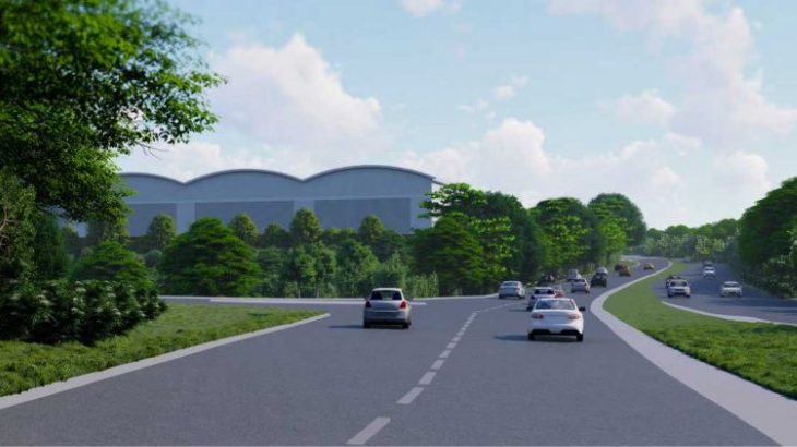
On the A5 north of Towcester a logistics company proposed a distribution centre and alongside, on the A43, another property developer proposed a mixed-use business/industrial park (Figure 1 above).
Until these proposals were revealed it was generally believed that Council Planners had protected the open countryside around Towcester from developments such as these super-sized sheds, more usually seen at motorway junctions.
Why permission has been granted is a question to be answered by the Councillors who sat on the committees that approved the Local Plan.
How the Council Planners justified the inclusion of these development sites in the Local Plan is set out below.
Background
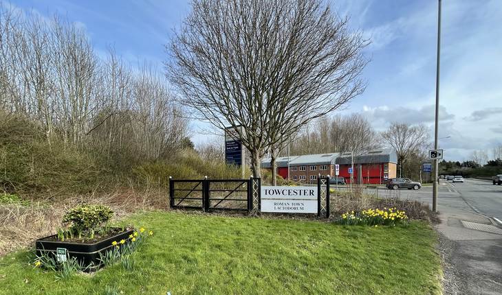
Since medieval times Towcester has existed as a market town on historic Watling Street, a strategically significant national transport route, now the A5. By the turn of the 21st century the town was losing its attractiveness. Through traffic was being held up in the town centre and at intersections; local traffic and pedestrians were struggling for access. Central area air quality was very poor. Behind the market square, buildings were standing empty, historic sites were overgrown and inaccessible, and the River Tove – which gave Towcester its name – was in a sorry state. Towcester needed regeneration.
At that time urban and regional planning was in the hands of Development Corporations, publicly funded specialists looking at the big picture of local needs and deciding what action to take to meet those needs.
For Towcester it was the West Northamptonshire Development Corporation that in 2004 took on the responsibility for planning its evolution into a modern market town, successful enough to serve the needs of everyone living in the local area for the next 25 years. The close involvement of residents was seen as crucial for ensuring the successful delivery of the plan, so the local Council invited contributions to a future Vision for Towcester at the earliest planning stage (Figure 2).

The Towcester Masterplan
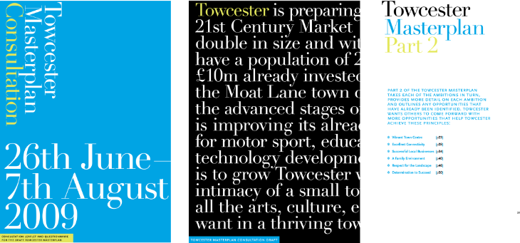
By the summer of 2009 a draft of the Towcester Masterplan was ready for public consultation. A detailed questionnaire1 with supporting documents (Figure 3) clearly set out and explained the Masterplan proposals2,3. Public exhibitions, attended by Council staff to answer questions, added further to the effective public communication of the proposals within the Masterplan.
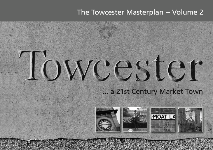
In 2011, following these lengthy consultations, South Northamptonshire Council formally adopted two volumes of the Towcester Masterplan4,5 (Figure 4). It was designed to guide Towcester’s future development up to 2026.

Setting a green boundary
A key feature of the Towcester Masterplan for 2026 was the acknowledgement that:
The town will grow, but will have a clear ‘green edge’, that sets a maximum limit to this growth, sets a boundary and ensures that urban sprawl is prevented. Areas around Easton Neston and Caldecote are particularly sensitive.
(Vol. 1, p. 80)
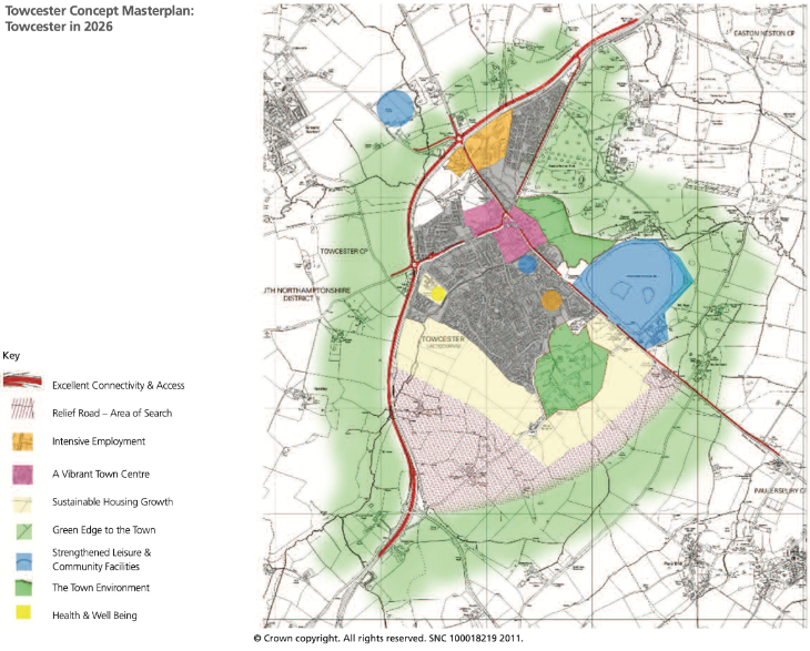
In line with this principle, the Masterplan shows Towcester surrounded by its ‘Green Edge’, there to prevent sprawling growth. The snake-like red line running from the bottom left, up and out at the top right edge in Figure 5 below is the very heavily trafficked A43 dual carriageway that connects Brackley, via J15a of the M1, to Northampton. Built in the 1980s this is the 'Northern Bypass' that took through traffic well away from the town, though it couldn't divert drivers on the A5, Watling Street, the very straight red line running diagonally down to the right of the diagram.
All change: the introduction of ‘Localism’
In 2011 the Localism Act6 abolished Development Corporations and transferred their plan-making role to local authorities. It became the duty of District and Town Councils to work with neighbouring authorities on regional planning issues and Daventry, Northampton and South Northamptonshire councils set up a Joint Planning Unit .
The Joint Planning Unit, like the predecessor Development Corporation, looked at the big picture of local needs, decided what action to take to meet those needs and formulated an area-wide strategic development plan they called the West Northamptonshire Joint Core Strategy Local Plan (Part 1)7 (Figure 6). Each of the three individual councils was then expected to go ahead and formulate their own Part 2 Local Plans.
For Towcester, the strategy was to promote the town as a Rural Service Centre, with new homes south of the town in a Sustainable Urban Extension – precisely as agreed in the earlier Towcester Masterplan. Residents like me were particularly reassured to read:
The landscape setting of Towcester is considered to be of medium sensitivity due to the surrounding historic parks, gardens, ancient woodland and topography. The areas around Easton Neston and Caldecote are particularly sensitive. 7
(Section 14.3)
South Northamptonshire Local Plan Part 2
So, while Towcester’s central regeneration was underway, officers at South Northamptonshire Council began adding features to their Local Plan Part 2. Arguments for the location of development sites were based, they wrote, on the Towcester Masterplan.
A new employment area
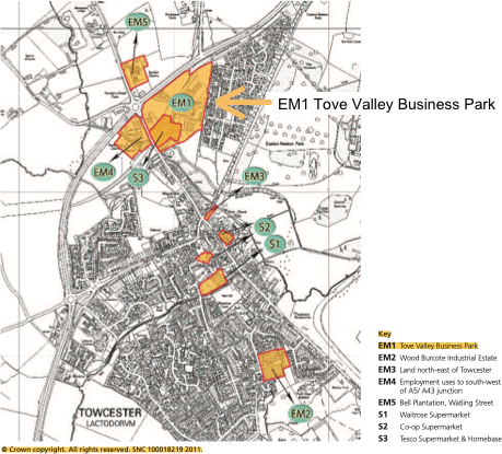
In their 2017 Part 2 draft they identified sites north of the A43 Towcester Bypass as offering ‘an opportunity for business and general industrial development’ (p. 123). This could have arisen from a labelling error on a diagram on page 30 of the Masterplan Volume 2, which wrongly located part of the 16-hectare Tove Valley Business Park as extending north beyond the Towcester Bypass, alongside the Bell Plantation garden centre on the A5 and at Daventry Road Farm (the Woolgrowers’ Field) opposite, as shown in Figure 7.
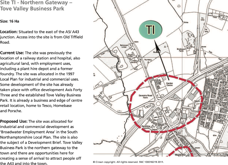
The correct location of Tove Valley Business Park appears in the Masterplan Volume 1 (page 46) where it is clearly separated from the Bell Plantation by the A43 Bypass (Figure 8).
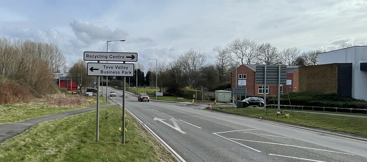
The photographs in Figure 9 confirm the actual location of The Northern Gateway – Tove Valley Business Park, signposted south, not north of the A43/A5 junction as South Northamptonshire Council mistakenly stated. As the home to Tesco, Loughran Brothers, B & M, Screwfix, Porsche and others, residents will be very familiar with the Tove Valley Business Park.
Having justified this new employment area the Council in their next draft of the Local Plan Part 2, went on to identify an additional, adjacent site for development, solely on the grounds that it sat alongside.
The South Northamptonshire Local Plan Part 2, 2011–20298 was completed and unanimously adopted at an online meeting of the South Northamptonshire Council in 20209, largely unnoticed by a country in Covid lockdown.
Other than the Councillors present at that adoption meeting, few people were aware that sites for future development had been allocated in the Masterplan’s ‘Green Edge’, a fact only revealed when planning applications for massive warehouses were submitted.
Compare and contrast the earlier elaborate public participation exercises leading up to agreeing the Towcester Masterplan with South Northamptonshire Council’s public engagement on behalf of their 2020 Local Plan.
Seeing the bigger picture
The enormous scale of these development sites can be seen in Figure 10. At around a fifth of the size of the existing town, their dominating presence, and the extra traffic they'll create, will irreversibly alter the character that once had been the key attraction of Towcester and its surrounding open countryside.
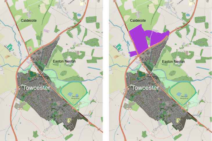
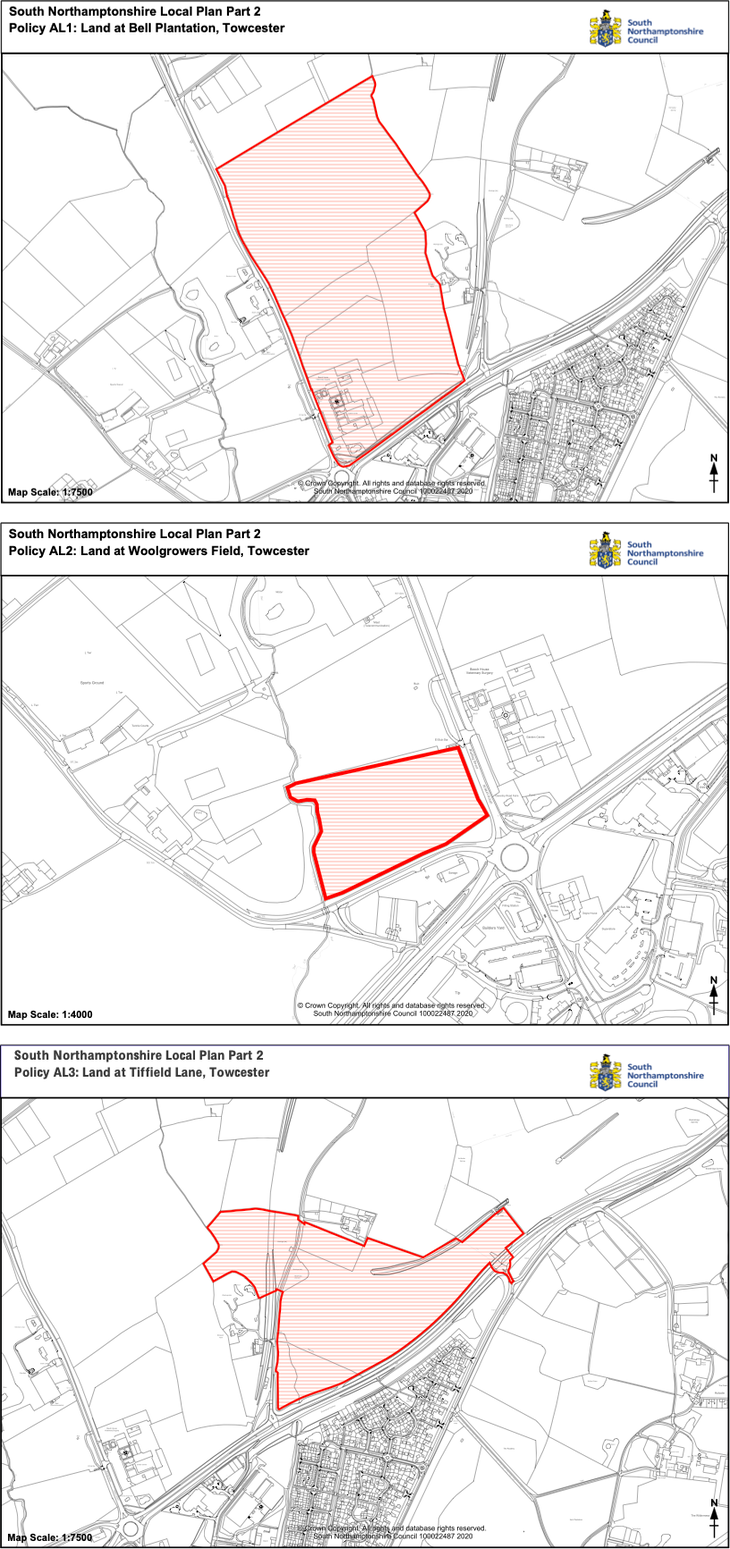
These commercial development sites were never published in their full context like this, which might explain why so few people were aware of their huge, combined size. All that had been seen of these site allocations, both by the public and probably by the South Northamptonshire and West Northamptonshire Council Planning Committees, were individual plans10 that indicated neither their relationship with one another nor their collective dominance of the local landscape. Rather than the big picture a set of individual diagrams (collected here in Figure 11) were all that was needed to meet the document submission requirement of the Planning Inspectorate.
These new development sites were facilitated by quoting selectively from the Towcester Masterplan:
The Towcester Masterplan – Volume 2, adopted by the council in March 2011 to guide regeneration proposals in Towcester, identifies parts of the Bell Plantation and Woolgrowers site as being within the ‘Tove Valley Business Park’ (Site TI - Northern Gateway) …
(Local Plan Part 2, Section 13.2.2)
In fact, as shown in Figure 8 above, the Towcester Masterplan did not identify parts of the Bell Plantation and Woolgrowers site as being within the Tove Valley Business Park, a significant error in the evidence submitted by the Council to the Planning Inspectorate.
Conclusion
This may read as a personal Not In My Back Yard tirade. And it’s true, Easton Neston Parish has had to work hard to protect its Conservation Area status. Land speculators have ‘form’ in this area. Innocent people a few years ago were duped into investing in what were wrongly claimed to be potential house-plots in the fields around the Parish – the scammers were jailed.
But for the 22,000 or so residents of Towcester and the surrounding communities the practical outcome of this Local Plan is blight. In planning terms ‘blight’ occurs when a potential development reduces property values. Nearby residents will see their homes devalued by the impact of noise, air and light pollution from whatever activity takes place in these new industrial sites, from earliest construction phases to regular commercial operations.
For other residents of Towcester, a new site access roundabout on the A43 east of the town will create a shortcut for traffic into and through the town. This entirely predictable, newly generated volume of two-way traffic will blight the regenerated heart of Towcester, further damage its air quality and generally harm its long-term commercial prospects.
To sum up more generally for West Northamptonshire: when the details in the new Local Plan emerge into daylight, they will need the closest of scrutiny to ensure that they don't deliver the negative outcomes that face Towcester and surrounding communities.
References
Ref 1 Consultation Leaflet and Questionnaire for the draft Towcester Masterplan August 2009 - South Northamptonshire Council
Ref 2 The Towcester Masterplan Consultation – Volume 1 2011 - South Northamptonshire Council
Ref 3 The Towcester Masterplan Consultation – Volume 2 2011 - South Northamptonshire Council
Ref 4 The Towcester Masterplan – Volume 1 2011 - South Northamptonshire Council
Ref 5 The Towcester Masterplan – Volume 2 2011 - South Northamptonshire Council
Ref 6 Ref 6 Localism Act 2011 - HM Government Legislation [Department for Communities and Local Government]
Ref 7 South Northamptonshire Local Plan Part 1 – 2014 - South Northamptonshire Council
Ref 8 South Northamptonshire Local Plan Part 2 2011-2029 – 2020 - South Northamptonshire Council
Ref 9 Minutes of a meeting of the Council held as a Remote meeting on Wednesday 2 July 2020 at 6.00 pm.
Ref 10 South Northamptonshire Local Plan (Part 2) 2011–2029 Appendix 1: Proposals Maps Policies - 2020 South Northamptonshire Council