
Local Nature Recovery Strategy
CA-WN submitted a response to the WNC consultation on the Local Nature Recovery Strategy that invited us to get involved, share our ideas, and be part of something amazing for our natural environment. We hope many other local individuals and groups did too. Now we await the outcome of the consultation.
Context
The global and national biodiversity crises are presented as the context for the West Northamptonshire Local Nature Recovery Strategy (LNRS).
The LNRS refers to the updated goals set out in law by the Environment Act 2021, which acknowledges the principles of the Lawton Report (2010)1 i.e. to increase the size and improve the diversity of existing sites, create new habitat areas and increase the connectivity and protection of different habitat zones. The strategy has goals to protect species as well as the heritage and cultural aspects of landscapes.
The LNRS aims to increase habitat and biodiversity–rich areas from 7% to 30% by 20302 across these landscape types: woodlands, grasslands, farmland, wetlands and urban areas. It aims to increase woodland cover from 5.8% to 21% and to prioritise 57 threatened species of plants and animals across the same landscapes.
Insight into the landscapes of West Northamptonshire
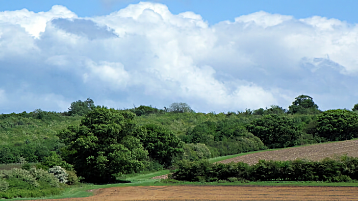
Landscapes form the foundation of our natural world. A natural landscape consists of landforms, such as hills and valleys, drainage features including lakes, streams, marsh and rivers, soils (e.g. silt, sand or clay), and natural vegetation. The topography or shape of the land and drainage is likely to be influenced by underlying geology and surface processes such as weathering, erosion and deposition. The features of landscapes are crucial factors in determining the nature of soils, ecosystems and their associated habitats, fauna and flora. Landscape characteristics will guide the restoration of Nature specific to those areas.
Natural England3 has divided England into 159 National Character Areas (NCAs).
Each NCA represents an area of distinct and recognisable character at the national scale. Their boundaries follow natural lines in the landscape, not county or district boundaries.
The West Northamptonshire landscape has been divided into 3 main National Character Areas: The Northamptonshire Uplands, The Nene Valley and the Yardley – Whittlewood Ridge (as shown in the diagram below):
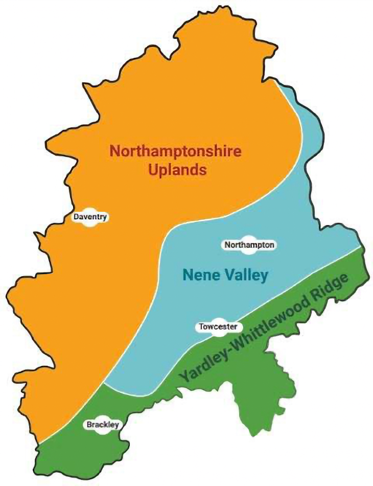
There are detailed descriptions of each NCA and associated landscapes, habitats and species and the important features of heritage such as ridge and furrow, ancient woodland, a parkland with significant trees characteristic of stately homes and a RAMSAR3 wetland site – the intergovernmental wetland treaty adopted in Ramsar, Iran in 1971 .
Understanding the intricacies of any landscape area can inform the habitat and wildlife needs of that area and so provide focus for local groups actioning Nature Recovery.
Priorities and Measures
The priorities in the LNRS define the key intentions or outcomes the strategy aims to achieve, while the measures it sets out are specific actions designed to deliver them.
There are 15 priorities: two are strategic and apply across the region of West Northamptonshire. They relate to the Lawton Principles; improved conservation management of existing sites important for habitat and wildlife, the creation of new sites to expand the area dedicated to Nature, and ensuring connectivity between sites to reduce fragmentation of habitats. Other priority aims refer to specific but broad habitat types: farmland (the most extensive and least diverse), woodland, grassland, freshwater and wetland, and urban. There are also species-specific priorities.
All priorities are set out on page 40 of the draft strategy.
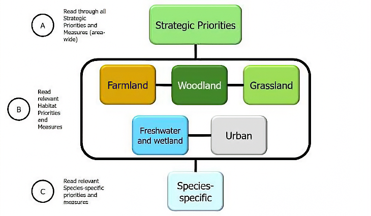
The following diagram can be found on page 8, which illustrates the overarching regional priorities, the habitat focus and the species-specific priorities and measures required.
Each priority aim will be achieved by a number of measures or actions and set out as in the following example:
Priority 1: Conserve, enhance, and reduce the pressures on existing designated sites.
Two of the six measures for this priority action are shown below. Measure 1 is mapped on the Local Habitat map, highlighting the existing sites for enhancement. There are measures which are species-specific with the symbol ◊.
|
1 |
Survey, provide landowner advice, and
facilitate habitat improvements on priority potential wildlife sites. ∆ |
|
2 |
Conserve, enhance and restore Local
Nature Reserves and Local Wildlife Sites, bringing them into positive and
sustainable management. |
PLEASE NOTE:
The LNRS aims to involve a wide range of stakeholders from landowners to businesses, community groups and individuals. However, there are details given of the permissions needed and constraints that may need to be sought and addressed in planning to take action. Please consult the supporting Permits, Consents and Permissions document.
Local Habitat Map
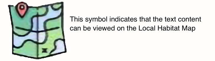
Throughout the draft strategy the Local Habitat Map symbol indicates that the text content can be viewed on the map.
The Local Habitat Map can be expanded to allow focus on a particular locality. The legend covers Areas of Particular Importance for Biodiversity (APIB) – the protected sites, the Areas that Could become Important for Biodiversity (ACB) and then a comprehensive coverage of all priorities and measures and therefore how biodiversity enhancement is possible.
Each button refers to a statement. Click on the statement by the button to reveal the area of interest and click a second time to disable that information.
The opening button gives the extent of ‘Areas of Particular Importance for Biodiversity’ (APIB) but further down the statement ‘Areas that Could become Important for Biodiversity (ACB) illustrate both the current sparsity of habitat across the region but also the astonishing potential for Nature enhancement if there is a real urgency of intention to do so.
The map key or legend is then set up with all priorities classed as shown in the diagram on page 8 starting with the strategic overall priorities. Buttons against each priority show where the measures can be actioned. With a careful application of each measure, it is easy to see how a habitat can be expanded across the region.
The National Character areas can be designated on the map and so a picture of potential habitat extension and creation can be illustrated for each area. This should assist with local planning for action in that habitats and therefore species can be related to the NCA containing the locality.
General points
Any group committed to the enhancement of habitats and species across West Northants will rely on the LNRS as a tool for ideas and actions.
It is worth giving time to its reading
Any actions planned will need commitment, time and probably money.
Achieving any major change requires the same.
The Nature and Climate crises are intricately woven: in supporting the recovery of Nature we create the resilience needed to mitigate against the other.
To have your say by 25 March complete this online survey or email the Council at naturerecovery@westnorthants.gov.uk or write to:
Ruth Rolls
West Northamptonshire Council
One Angel Square, Angel Street (Service Yard)
Northampton
NN1 1ED
Our nature needs you.
REFERENCES:
1 https://www.gov.uk/government/news/making-space-for-nature-a-review-of-englands-wildlife-sites-published-today
2 https://www.cbd.int/gbf
3 RAMSAR CONVENTION 1971 https://www.ramsar.org/